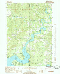
1985 Map of Big Bend
USGS Topo · Published 1985About this map
The Muskegon River carves a dramatic oxbow through this mid-1980s landscape, centered on the Big Bend area where the river widens into the Hardy Dam Pond. This reach of the river is characterized by extensive public lands, with the Manistee National Forest covering much of the northern terrain and Newaygo State Park situated along the southern shoreline. The map reveals the recreational and industrial character of the region, identifying several riverside campsites and the Oxbow Park, alongside evidence of resource extraction such as an Oil Field and scattered Oil Wells. The small settlement of Bennett and a lakeside Cem provide important points of reference for local historians. Numerous small glacial lakes like Carey Lake and Round Lake dot the forested upland, feeding into tributaries like Betts Creek and South Mitchell Creek.
Find a feature on this map
34 named features on this map. Tap any name to fly to it.
Don’t see what you’re looking for? This feature index may not catch every label — zoom into the map to look around manually.
Map Details
Editions of this 1985 Big Bend Map
This is the sole edition of this map. No revisions or reprints were ever made.
Other maps of this area

1954 · Midland
USGS Topo · 1:250,000

1958 · Midland
USGS Topo · 1:250,000

1958 · Sand Lake
USGS Topo · 1:62,500

1958 · Woodville
USGS Topo · 1:62,500

1958 · Big Rapids
USGS Topo · 1:62,500

1959 · Midland
USGS Topo · 1:250,000

1959 · Howard City
USGS Topo · 1:62,500

1966 · Midland
USGS Topo · 1:250,000

1976 · Big Rapids SW
USGS Topo · 1:24,000
1976 · Howard City NW
USGS Topo · 1:24,000