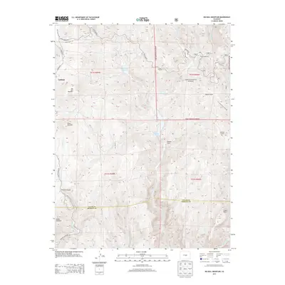
2013 Map of Big Bull Mountain
USGS Topo · Published 2013About this map
Big Bull Mountain stands as a central landmark in this high-altitude landscape of southern Colorado, where the boundary between Teller and Fremont Counties cuts through a network of drainages and peaks. The map details the transition from the settlement at Goldfield into the protected expanses of the Pike National Forest. Water management is prominent through features like Skaguay Reservoir and Pringtime Reservoir, which serve a region defined by steep gulches such as Douglas Gulch and Hopkins Gulch. Transport through this challenging terrain is facilitated by historic corridors like Gold Camp Rd and the winding Phantom Canyon Rd, the latter tracing the path of Eightmile Creek. This 2013 survey provides a clear view of the modern infrastructure and natural topography surrounding established sites like Clyde and its associated Clyde Campground.
Find a feature on this map
38 named features on this map. Tap any name to fly to it.
Don’t see what you’re looking for? This feature index may not catch every label — zoom into the map to look around manually.
Map Details
Editions of this 2013 Big Bull Mountain Map
This is the sole edition of this map. No revisions or reprints were ever made.
Other maps of this area

1893 · Colorado Springs
USGS Topo · 1:125,000

1894 · Pikes Peak
USGS Topo · 1:125,000

1901 · Pikes Peak
USGS Topo · 1:125,000

1901 · Pikes Peak
USGS Topo · 1:62,500

1909 · Colorado Springs
USGS Topo · 1:125,000

1942 · Colorado Springs
USGS Topo · 1:125,000

1948 · Mount Big Chief
USGS Topo · 1:24,000

1948 · Mount Pittsburg
USGS Topo · 1:24,000

1948 · Manitou Springs
USGS Topo · 1:24,000

1948 · Colorado Springs
USGS Topo · 1:62,500