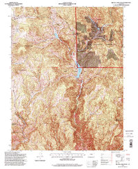
1994 Map of Big Bull Mountain
USGS Topo · Published 1998About this map
The settlement of Goldfield sits on the western edge of this topographic survey, marking a legacy of mineral extraction that continues into the 1990s as indicated by the broad Mining Area nearby. This high-altitude landscape in the Pike National Forest is defined by a series of prominent peaks, including Big Bull Mountain, Brind Mountain, and Nipple Mountain. The central drainage is dominated by the Skaguay Reservoir, which collects the waters of Middle Beaver Creek as it flows south toward the Beaver Creek State Wildlife Area.
Find a feature on this map
20 named features on this map. Tap any name to fly to it.
Don’t see what you’re looking for? This feature index may not catch every label — zoom into the map to look around manually.
Map Details
Editions of this 1994 Big Bull Mountain Map
This is the sole edition of this map. No revisions or reprints were ever made.
Other maps of this area

1893 · Colorado Springs
USGS Topo · 1:125,000

1894 · Pikes Peak
USGS Topo · 1:125,000

1901 · Pikes Peak
USGS Topo · 1:125,000

1901 · Pikes Peak
USGS Topo · 1:62,500

1909 · Colorado Springs
USGS Topo · 1:125,000

1942 · Colorado Springs
USGS Topo · 1:125,000

1948 · Mount Big Chief
USGS Topo · 1:24,000

1948 · Mount Pittsburg
USGS Topo · 1:24,000

1948 · Manitou Springs
USGS Topo · 1:24,000

1948 · Colorado Springs
USGS Topo · 1:62,500