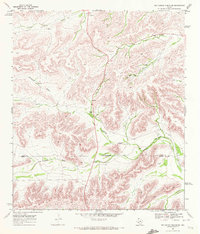
1969 Map of Big Canyon Ranch SW
USGS Topo · Published 1972About this map
Mitchell Ranch serves as the central landmark in this high-desert ranching landscape at the intersection of several significant seasonal watercourses. The terrain is defined by the carved paths of Clark Place Draw, Fortyone Draw, and Downie Draw, which create a complex network of drainage basins across the West Texas scrub. An Indefinite Boundary separates Pecos Co and Terrell Co, illustrating the administrative challenges of surveying this remote frontier. Sparse human infrastructure is limited to a handful of Gravel Pits and a Corral, reflecting a landscape dedicated almost exclusively to large-scale livestock operations in the late 1960s. The map provides a look at the essential isolation of the region, where life is organized around the rare, intermittent water provided by the draws.
Find a feature on this map
8 named features on this map. Tap any name to fly to it.
Don’t see what you’re looking for? This feature index may not catch every label — zoom into the map to look around manually.
Map Details
Editions of this 1969 Big Canyon Ranch SW Map
This is the sole edition of this map. No revisions or reprints were ever made.
Other maps of this area

1920 · Longfellow
USGS Topo · 1:125,000

1928 · Sanderson
USGS Topo · 1:125,000

1954 · Fort Stockton
USGS Topo · 1:250,000

1958 · Fort Stockton
USGS Topo · 1:250,000

1968 · Busher Canyon
USGS Topo · 1:24,000

1968 · Toms Canyon
USGS Topo · 1:24,000

1968 · Ninemile Ranch
USGS Topo · 1:24,000

1969 · Sanderson
USGS Topo · 1:24,000

1969 · Big Canyon Ranch
USGS Topo · 1:24,000

1969 · Big Canyon Ranch NW
USGS Topo · 1:24,000