
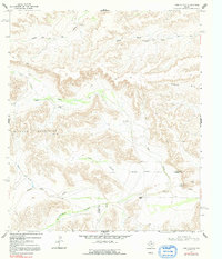
1968 Map of Toms Canyon
USGS Topo · Published 1971About this map
Downie Ranch sits at the base of a complex drainage network in West Texas, where the high desert terrain is defined by seasonal washes and isolated water sources. This 1968 survey highlights the critical importance of water infrastructure in the arid Wildcat Mountains region, documenting scattered livestock improvements such as Cliett Windmills, Baker Windmill, and the Yerbabuena Windmill. The landscape is carved by deep erosional features like Toms Canyon and Pyle Draw, which converge near the Pecos and Terrell County line. Notable landmarks for navigation include the prominent Two Top Mountain and Standifer Gap, alongside specialized infrastructure like the Joes Booster Windmill and various cattle-handling sites such as Rock Pens Windmill. The map's detail reveals the intersection of topography and ranching life, tracing how family-named draws like Downie Draw and Clark Place Draw shaped the development of these remote holdings.
Find a feature on this map
20 named features on this map. Tap any name to fly to it.
Don’t see what you’re looking for? This feature index may not catch every label — zoom into the map to look around manually.
Map Details
Editions of this 1968 Toms Canyon Map
2 editions found
Other maps of this area

1920 · Longfellow
USGS Topo · 1:125,000

1928 · Sanderson
USGS Topo · 1:125,000

1954 · Fort Stockton
USGS Topo · 1:250,000

1958 · Fort Stockton
USGS Topo · 1:250,000

1968 · Busher Canyon
USGS Topo · 1:24,000

1968 · F C Ranch
USGS Topo · 1:24,000

1968 · Longfellow
USGS Topo · 1:24,000

1968 · Ebers Camp
USGS Topo · 1:24,000

1968 · Ninemile Ranch
USGS Topo · 1:24,000

1969 · Sanderson
USGS Topo · 1:24,000