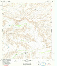
1968 Map of Toms Canyon
USGS Topo · Published 1992About this map
The Wildcat Mountains dominate this high-desert landscape of the Trans-Pecos, where a network of dry washes and named canyons define the local geography. Surveyed in the late 1960s, the map reveals an arid ranching economy dependent on dispersed water sources, marked by several family-named wells including Cliett Windmills, Baker Windmill, and Joes Rooster Windmill. The terrain is characterized by deep dissection, where Middle Fork Big Canyon and Toms Canyon carve through the plateau toward the south and east.
Find a feature on this map
20 named features on this map. Tap any name to fly to it.
Don’t see what you’re looking for? This feature index may not catch every label — zoom into the map to look around manually.
Map Details
Editions of this 1968 Toms Canyon Map
2 editions found
Other maps of this area

1920 · Longfellow
USGS Topo · 1:125,000

1928 · Sanderson
USGS Topo · 1:125,000

1954 · Fort Stockton
USGS Topo · 1:250,000

1958 · Fort Stockton
USGS Topo · 1:250,000

1968 · Busher Canyon
USGS Topo · 1:24,000

1968 · Toms Canyon
USGS Topo · 1:24,000

1968 · F C Ranch
USGS Topo · 1:24,000

1968 · Longfellow
USGS Topo · 1:24,000

1968 · Ebers Camp
USGS Topo · 1:24,000

1968 · Ninemile Ranch
USGS Topo · 1:24,000