
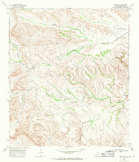
1968 Map of Longfellow
USGS Topo · Published 1971About this map
Longfellow serves as the focal point of this Trans-Pecos landscape during the late 1960s, situated where the Southern Pacific railroad cuts through the arid terrain of the Pecos and Brewster County line. The settlement pattern is defined by isolated outposts like Steer Wells and the infrastructure of West Texas ranching, with numerous water catchments such as Haystack Tank, Gap Tank, and Silver Lake scattered across the draws. The geography is characterized by complex drainages including Yolts Draw, Downie Draw, and Javelina Draw, all feeding into the larger systems of Sanderson Creek and Dry Creek. Prominent landmarks such as Panther Peak rise above the surrounding Rattlesnake Flats, while a network of Jeep Trails provides access to remote corners of Sanderson Canyon, reflecting the rugged, utilitarian nature of the region's transport and water management during this era.
Find a feature on this map
19 named features on this map. Tap any name to fly to it.
Don’t see what you’re looking for? This feature index may not catch every label — zoom into the map to look around manually.
Map Details
Editions of this 1968 Longfellow Map
This is the sole edition of this map. No revisions or reprints were ever made.
Other maps of this area

1920 · Longfellow
USGS Topo · 1:125,000

1954 · Fort Stockton
USGS Topo · 1:250,000

1958 · Fort Stockton
USGS Topo · 1:250,000

1968 · Cap Rock Butte
USGS Topo · 1:24,000

1968 · Big Brindle Canyon
USGS Topo · 1:24,000

1968 · Toms Canyon
USGS Topo · 1:24,000

1968 · F C Ranch
USGS Topo · 1:24,000

1968 · Fresno Creek
USGS Topo · 1:24,000
1968 · Tesnus SE
USGS Topo · 1:24,000

1968 · Ninemile Ranch
USGS Topo · 1:24,000