
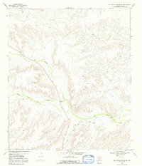
1969 Map of Big Canyon Ranch NW
USGS Topo · Published 1972About this map
Big Canyon and the Middle Fork Big Canyon dominate this Trans-Pecos landscape, carving deep drainage patterns through the high ground known as the Big Divide. This 1960s survey captures a working ranching environment where water management and elevation dictated the placement of remote outposts. The map documents established family operations such as Thorn Ranch in the north and Mitchell Ranch further south along the canyon floor.
Find a feature on this map
9 named features on this map. Tap any name to fly to it.
Don’t see what you’re looking for? This feature index may not catch every label — zoom into the map to look around manually.
Map Details
Editions of this 1969 Big Canyon Ranch NW Map
2 editions found
Other maps of this area

1920 · Longfellow
USGS Topo · 1:125,000

1928 · Sanderson
USGS Topo · 1:125,000

1928 · Comanche Spring
USGS Topo · 1:125,000

1929 · Independence Draw Quadrangle
USGS Topo · 1:125,000

1954 · Fort Stockton
USGS Topo · 1:250,000

1958 · Fort Stockton
USGS Topo · 1:250,000

1968 · Busher Canyon
USGS Topo · 1:24,000

1968 · Toms Canyon
USGS Topo · 1:24,000

1969 · Big Canyon Ranch
USGS Topo · 1:24,000
1969 · Big Canyon Ranch SW
USGS Topo · 1:24,000