
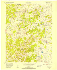
1949 Map of Big Clifty
USGS Topo · Published 1952About this map
Big Clifty serves as the primary hub of activity in this 1949 survey, situated along the Illinois Central railroad corridor that defines the local economy and transport network. This rural landscape on the border of Hardin and Grayson Counties is marked by a high density of small community centers, each typically anchored by a neighborhood school or church. Features such as the St Pauls Sch, Burkhead Sch, and Flatwoods Sch are scattered throughout the hills, providing a clear map of rural education patterns before the era of major district consolidation. To the north and west, the terrain becomes increasingly complex as it drops toward Rough Creek and Meeting Creek, where isolated settlements like Limp and Solway occupy the high ground between winding stream valleys. The detailed mapping of family-named landmarks like Ripstin Ridge and cemeteries such as St Elizabeth Cem offers significant value for those tracing local lineages.
Find a feature on this map
35 named features on this map. Tap any name to fly to it.
Don’t see what you’re looking for? This feature index may not catch every label — zoom into the map to look around manually.
Map Details
Editions of this 1949 Big Clifty Map
This is the sole edition of this map. No revisions or reprints were ever made.
Other maps of this area

1922 · Leitchfield
USGS Topo · 1:48,000

1925 · Cub Run
USGS Topo · 1:62,500

1925 · Leitchfield
USGS Topo · 1:62,500

1932 · Big Clifty
USGS Topo · 1:62,500

1949 · Constantine
USGS Topo · 1:24,000

1949 · Summit
USGS Topo · 1:24,000
1949 · Howe Valley
USGS Topo · 1:24,000

1949 · Big Clifty
USGS Topo · 1:62,500

1953 · Custer
USGS Topo · 1:24,000

1954 · Evansville
USGS Topo · 1:250,000