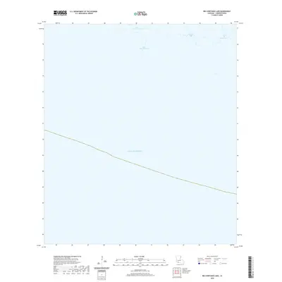
2020 Map of Big Constance Lake
USGS Topo · Published 2020About this map
The coastal marshlands of Cameron Parish are defined by a network of tidal waterways at the edge of the Gulf of Mexico. Small bodies of water, including Little Constance Lake, are linked by a series of narrow channels such as Little Constance Bayou and Constance Bayou. These low-lying wetlands represent the fragile interface between the southern Louisiana mainland and the open sea. Farther east, Dyson Bayou meanders through the terrain, illustrating the complex hydrography of this littoral zone. The absence of roads or permanent structures on this map highlights the natural state of the landscape, where the shifting boundaries of water and land dictate the character of the region.
Find a feature on this map
5 named features on this map. Tap any name to fly to it.
Don’t see what you’re looking for? This feature index may not catch every label — zoom into the map to look around manually.
Map Details
Editions of this 2020 Big Constance Lake Map
This is the sole edition of this map. No revisions or reprints were ever made.
Other maps of this area

1932 · Constance Bayou NE
USGS Topo · 1:31,680

1932 · Constance Bayou SW
USGS Topo · 1:31,680

1932 · Constance Bayou SE
USGS Topo · 1:31,680

1932 · Constance Bayou NW
USGS Topo · 1:31,680

1946 · Hog Bayou NE
USGS Topo · 1:31,680

1949 · Hog Bayou NE
USGS Topo · 1:31,680
1954 · Constance Bayou SE
USGS Topo · 1:31,680
1954 · Constance Bayou NW
USGS Topo · 1:31,680
1954 · Constance Bayou SW
USGS Topo · 1:31,680

1954 · Port Arthur
USGS Topo · 1:250,000