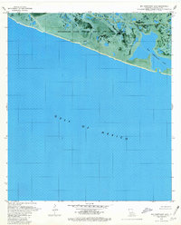
1979 Map of Big Constance Lake
USGS Topo · Published 1980About this map
Rockefeller State Wildlife Refuge and Game Preserve dominates this coastal landscape where the Louisiana marsh meets the Gulf of Mexico. This 1970s orthophotomap combines aerial photography with topographic data to document a fluid environment of brackish lakes and meandering waterways. The intricate hydrology of Little Constance Lake and the larger Big Constance Lake is shaped by natural features like Constance Bayou and Dyson Bayou, alongside industrial modifications such as the Pipeline Canal in the northwest. The transition between the open waters of the Gulf and the interior wetlands of Cameron Parish is captured with precision, showing the delicate barrier between the sea and the preserve's managed habitats.
Find a feature on this map
8 named features on this map. Tap any name to fly to it.
Don’t see what you’re looking for? This feature index may not catch every label — zoom into the map to look around manually.
Map Details
Editions of this 1979 Big Constance Lake Map
This is the sole edition of this map. No revisions or reprints were ever made.
Other maps of this area

1932 · Constance Bayou NE
USGS Topo · 1:31,680

1932 · Constance Bayou SW
USGS Topo · 1:31,680

1932 · Constance Bayou SE
USGS Topo · 1:31,680

1932 · Constance Bayou NW
USGS Topo · 1:31,680

1946 · Hog Bayou NE
USGS Topo · 1:31,680

1949 · Hog Bayou NE
USGS Topo · 1:31,680
1954 · Constance Bayou SE
USGS Topo · 1:31,680
1954 · Constance Bayou NW
USGS Topo · 1:31,680
1954 · Constance Bayou SW
USGS Topo · 1:31,680

1954 · Port Arthur
USGS Topo · 1:250,000