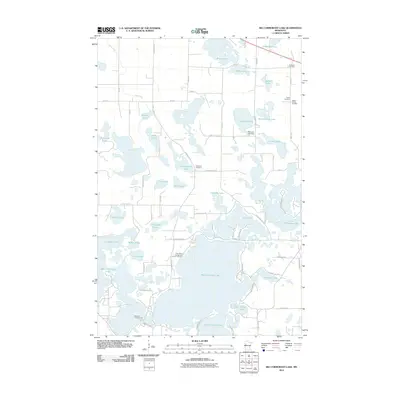
2010 Map of Big Cormorant Lake
USGS Topo · Published 2010About this map
Big Cormorant Lake and its neighboring basins define this corner of Becker County, where a dense network of glacial lakes and small creeks shapes the local landscape. The map reveals a high concentration of burial sites reflecting the area's pioneer roots, including the Audubon Cemetery, Strandvik Cemetery, and the Felker Family Cemetery. These sites, alongside larger bodies of water like Little Cormorant Lake and Upper Cormorant Lake, suggest a long history of seasonal recreation and established rural communities.
Find a feature on this map
70 named features on this map. Tap any name to fly to it.
Don’t see what you’re looking for? This feature index may not catch every label — zoom into the map to look around manually.
Map Details
Editions of this 2010 Big Cormorant Lake Map
This is the sole edition of this map. No revisions or reprints were ever made.
Other maps of this area

1912 · Vergas
USGS Topo · 1:62,500

1914 · Pelican Rapids
USGS Topo · 1:62,500

1915 · Vergas
USGS Topo · 1:62,500

1917 · Pelican Rapids
USGS Topo · 1:62,500

1953 · Fargo
USGS Topo · 1:250,000

1953 · Brainerd
USGS Topo · 1:250,000

1956 · Fargo
USGS Topo · 1:250,000

1957 · Brainerd
USGS Topo · 1:250,000

1958 · Brainerd
USGS Topo · 1:250,000
1959 · Callaway
USGS Topo · 1:24,000