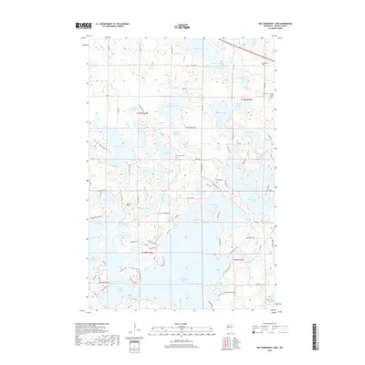
2019 Map of Big Cormorant Lake
USGS Topo · Published 2019About this map
Big Cormorant Lake dominates the central landscape of this Becker County quadrangle, surrounded by a dense network of smaller basins and glacial potholes that define the region's hydrography. The distribution of Audubon Cem, Strandvik Cem, and the Felker Family Cem near the northern waters of Felker Lake and Boyer Lake provides essential coordinates for genealogical research in this part of Minnesota. The map details a modern rural infrastructure of county roads and named avenues like 140th Ave, indicating the long-standing importance of these routes for lake access and local commerce. Further south, Kaiser's Airstrip near Hougland Lake marks a point of private aviation, while the complex shorelines of Upper Cormorant Lake and Middle Cormorant Lake illustrate the intricate water system that has historically shaped recreation and settlement in the area.
Find a feature on this map
93 named features on this map. Tap any name to fly to it.
Don’t see what you’re looking for? This feature index may not catch every label — zoom into the map to look around manually.
Map Details
Editions of this 2019 Big Cormorant Lake Map
This is the sole edition of this map. No revisions or reprints were ever made.
Other maps of this area

1912 · Vergas
USGS Topo · 1:62,500

1914 · Pelican Rapids
USGS Topo · 1:62,500

1915 · Vergas
USGS Topo · 1:62,500

1917 · Pelican Rapids
USGS Topo · 1:62,500

1953 · Fargo
USGS Topo · 1:250,000

1953 · Brainerd
USGS Topo · 1:250,000

1956 · Fargo
USGS Topo · 1:250,000

1957 · Brainerd
USGS Topo · 1:250,000

1958 · Brainerd
USGS Topo · 1:250,000
1959 · Callaway
USGS Topo · 1:24,000