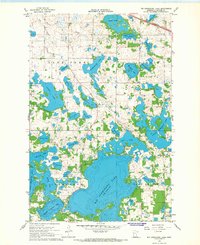
1966 Map of Big Cormorant Lake
USGS Topo · Published 1967About this map
Glacial geology defines this portion of Becker County, where a dense cluster of kettle lakes dominates the landscape in the mid-1960s. Big Cormorant Lake serves as the central geographic feature, surrounded by dozens of smaller named bodies including Starke Lake, Leaf Lake, and the poetically named Forget-me-not Lake. This period shows the transition between the agricultural upland and protected wetlands, notably the National Wildlife Management Area south of Hougland Lake.
Find a feature on this map
43 named features on this map. Tap any name to fly to it.
Don’t see what you’re looking for? This feature index may not catch every label — zoom into the map to look around manually.
Map Details
Editions of this 1966 Big Cormorant Lake Map
This is the sole edition of this map. No revisions or reprints were ever made.
Other maps of this area

1912 · Vergas
USGS Topo · 1:62,500

1914 · Pelican Rapids
USGS Topo · 1:62,500

1915 · Vergas
USGS Topo · 1:62,500

1917 · Pelican Rapids
USGS Topo · 1:62,500

1953 · Fargo
USGS Topo · 1:250,000

1953 · Brainerd
USGS Topo · 1:250,000

1956 · Fargo
USGS Topo · 1:250,000

1957 · Brainerd
USGS Topo · 1:250,000

1958 · Brainerd
USGS Topo · 1:250,000
1959 · Callaway
USGS Topo · 1:24,000