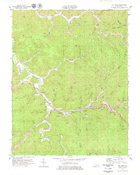
1979 Map of Big Creek
USGS Topo · Published 1979About this map
Red Bird River meanders through the heart of this landscape, its deep loops defining the topography of Clay County in the late 1970s. The region is marked by an extensive extraction economy, visible through numerous strip mines, mines, and a tipple located near Smithern Fk. Transportation is a central theme, as the Daniel Boone Parkway cuts across the terrain, accompanied by tollgates that indicate the infrastructure of the period.
Find a feature on this map
68 named features on this map. Tap any name to fly to it.
Don’t see what you’re looking for? This feature index may not catch every label — zoom into the map to look around manually.
Map Details
Editions of this 1979 Big Creek Map
This is the sole edition of this map. No revisions or reprints were ever made.
Other maps of this area

1891 · Manchester
USGS Topo · 1:125,000

1891 · Hazard
USGS Topo · 1:125,000

1913 · Buckhorn
USGS Topo · 1:62,500

1916 · Hyden
USGS Topo · 1:48,000

1919 · Hyden
USGS Topo · 1:62,500

1953 · Buckhorn
USGS Topo · 1:24,000

1953 · Oneida
USGS Topo · 1:24,000

1953 · Hyden West
USGS Topo · 1:24,000

1953 · Big Creek
USGS Topo · 1:24,000

1953 · Mistletoe
USGS Topo · 1:24,000