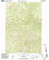
2004 Map of Big Creek
USGS Topo · Published 2007About this map
The Frank Church - River of No Return Wilderness dominates this map, where the high mountain terrain of the Payette National Forest meets the administrative and industrial markers of the early 21st century. This area, straddling the Idaho and Valley County line, was historically defined by its mineral wealth and remote access. Mining history is preserved through labels for the Golden Hand Mine, Werdenhoff Mine, and Golden Cup Mine, indicating a landscape once busy with prospecting. A critical node in this backcountry is Big Creek, supported by the Big Creek Guard Sta and a dedicated Landing Strip, which together signal the essential role of aviation and forest management in this roadless interior. Significant topographical landmarks like Ramey Ridge and Mosquito Ridge frame the drainage basins of Smith Creek and Beaver Creek.
Find a feature on this map
38 named features on this map. Tap any name to fly to it.
Don’t see what you’re looking for? This feature index may not catch every label — zoom into the map to look around manually.
Map Details
Editions of this 2004 Big Creek Map
This is the sole edition of this map. No revisions or reprints were ever made.
Other maps of this area

1937 · Big Creek
USGS Topo · 1:48,000

1942 · Big Creek
USGS Topo · 1:62,500

1956 · Elk City
USGS Topo · 1:250,000

1960 · Elk City
USGS Topo · 1:250,000

1969 · Edwardsburg
USGS Topo · 1:24,000

1969 · Profile Gap
USGS Topo · 1:24,000

1969 · Wolf Fang Peak
USGS Topo · 1:24,000

1969 · Big Creek
USGS Topo · 1:24,000

1973 · Center Mtn
USGS Topo · 1:24,000

1973 · Bismark Mtn
USGS Topo · 1:24,000