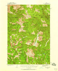
1937 Map of Big Creek
USGS Topo · Published 1958About this map
The Edwardsburg settlement and its adjacent Landing Field serve as the hub for this high-elevation backcountry, where the boundary between Idaho County and Valley County is defined by sharp peaks and ridgelines. Surveyed in the mid-1930s, the map reveals an economy driven almost entirely by remote mining operations and forestry. A series of deep-woods outposts including Hand Cabin, Mahan Cabin, and Estep Cabin are connected by the Smokehouse Trail and other primitive routes, suggesting a landscape of seasonal residency for prospectors and forest rangers. Hard-rock mining efforts are evident at the Werdenhoff Mine, Independence Mine, and the Goldman Cut, located near significant terrain features like Wolf Fang Peak and Mt Eldridge. The drainage systems of Big Creek and Logan Creek provide the primary corridors through this complex topography, punctuated by alpine landmarks such as Logan Lake and Fish Lake.
Find a feature on this map
85 named features on this map. Tap any name to fly to it.
Don’t see what you’re looking for? This feature index may not catch every label — zoom into the map to look around manually.
Map Details
Editions of this 1937 Big Creek Map
2 editions found
Other maps of this area

1937 · Yellow Pine
USGS Topo · 1:48,000

1937 · Big Creek
USGS Topo · 1:48,000

1942 · Big Creek
USGS Topo · 1:62,500

1943 · Yellow Pine
USGS Topo · 1:62,500

1956 · Warren
USGS Topo · 1:62,500

1956 · Elk City
USGS Topo · 1:250,000

1957 · Challis
USGS Topo · 1:250,000

1960 · Elk City
USGS Topo · 1:250,000

1960 · Challis
USGS Topo · 1:250,000

1963 · Challis
USGS Topo · 1:250,000