
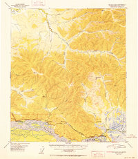
1952 Map of Big Delta B-5
USGS Topo · Published 1952About this map
The Tanana River dominates the southern reaches of this interior Alaskan landscape, serving as a vital geographical anchor for the settlements and transport routes established along its banks. The Richardson Highway parallels the river, connecting isolated outposts such as Richardson and Canyon Creek Camp. This corridor reveals a legacy of resource extraction and frontier transit, evidenced by a Mine (Aband) near Banner Creek and several remote dwellings including Campbell Cabin and the J Fowler Cabin. To the north, the terrain transitions into a complex network of drainages like Monte Cristo Creek and Minton Creek, while the eastern edge is defined by the marshy expanse of the Shaw Creek Flats. A Winter Trail in the northwest corner highlights the seasonal nature of travel in this region during the mid-twentieth century, before modern infrastructure fully bypassed these traditional paths.
Find a feature on this map
29 named features on this map. Tap any name to fly to it.
Don’t see what you’re looking for? This feature index may not catch every label — zoom into the map to look around manually.
Map Details
Editions of this 1952 Big Delta B-5 Map
2 editions found
Other maps of this area

1949 · Big Delta B-5
USGS Topo · 1:63,360

1949 · Big Delta B-6
USGS Topo · 1:63,360

1949 · Big Delta C-6
USGS Topo · 1:63,360

1949 · Big Delta A-6
USGS Topo · 1:63,360

1950 · Big Delta
USGS Topo · 1:250,000

1950 · Big Delta A-5
USGS Topo · 1:63,360

1950 · Big Delta A-4
USGS Topo · 1:63,360

1950 · Big Delta B-4
USGS Topo · 1:63,360

1951 · Big Delta
USGS Topo · 1:250,000
1951 · Big Delta A-6
USGS Topo · 1:63,360