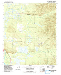
1992 Map of Big Delta C-6 SW
USGS Topo · Published 1992About this map
The Tanana River and the Little Salcha River define the lower wetlands of this Interior Alaska landscape, where modern energy infrastructure intersects with vast military training grounds. Much of the northern terrain is occupied by the Fort Wainwright Maneuver Area, a sprawling tactical space used by the U.S. Army. Cutting through the center of the sheet is the Trans-Alaska Pipeline, a critical piece of industrial history supported by Pumping Station No. 8 and its prominent stack. The transport network here relies on the Richardson Highway and Johnson Road, while various Winter Trails snake across the muskeg and drainages like French Creek. This 1990s-era documentation reflects the late 20th-century balance between the state's military importance and its role in the global petroleum economy.
Find a feature on this map
13 named features on this map. Tap any name to fly to it.
Don’t see what you’re looking for? This feature index may not catch every label — zoom into the map to look around manually.
Map Details
Editions of this 1992 Big Delta C-6 SW Map
This is the sole edition of this map. No revisions or reprints were ever made.
Other maps of this area

1949 · Big Delta B-6
USGS Topo · 1:63,360

1949 · Fairbanks C-1
USGS Topo · 1:63,360

1949 · Big Delta C-6
USGS Topo · 1:63,360

1950 · Fairbanks
USGS Topo · 1:250,000

1950 · Big Delta
USGS Topo · 1:250,000

1950 · Fairbanks C-1
USGS Topo · 1:63,360

1950 · Fairbanks B-1
USGS Topo · 1:63,360

1951 · Big Delta
USGS Topo · 1:250,000
1951 · Fairbanks B-1
USGS Topo · 1:63,360

1951 · Fairbanks
USGS Topo · 1:250,000