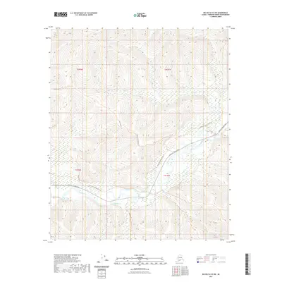
2021 Map of Big Delta D-5 NW
USGS Topo · Published 2021About this map
The Chena River winds through this interior Alaskan wilderness, serving as the central geographic feature of the Big Delta region. Modern transit is represented by Chena Hot Springs Road, which provides primary access to the area, while a series of traditional routes like the Chena Hot Springs Winter Trl and Stiles Creek Trl crisscross the landscape. These trails suggest a history of seasonal movement and resource access in a region defined by its waterway network. Several smaller tributaries, including Mastadon Cr, Stiles Cr, and Rock Cr, drain the surrounding uplands into the Chena valley. This map is particularly valuable for understanding the modern footprint of the Fairbanks North Star Borough's outlying recreation and wilderness areas, where historic winter trails intersect with contemporary road infrastructure.
Find a feature on this map
13 named features on this map. Tap any name to fly to it.
Don’t see what you’re looking for? This feature index may not catch every label — zoom into the map to look around manually.
Map Details
Editions of this 2021 Big Delta D-5 NW Map
This is the sole edition of this map. No revisions or reprints were ever made.
Other maps of this area

1950 · Big Delta
USGS Topo · 1:250,000

1950 · Big Delta D-6
USGS Topo · 1:63,360

1951 · Big Delta
USGS Topo · 1:250,000

1951 · Circle
USGS Topo · 1:250,000

1951 · Circle A-5
USGS Topo · 1:63,360

1952 · Big Delta D-6
USGS Topo · 1:63,360

1952 · Circle A-5
USGS Topo · 1:63,360

1954 · Circle A-6
USGS Topo · 1:63,360

1954 · Circle A-5
USGS Topo · 1:63,360

1955 · Circle
USGS Topo · 1:250,000