
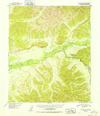
1952 Map of Big Delta D-6
USGS Topo · Published 1952About this map
The meandering Chena River dominates this interior Alaska landscape, carving a complex path through the terrain just years after the close of World War II. The river's character is defined by sharp bends and the presence of Mullen Slough, while its South Fork branches off into the higher elevations to the southeast. Human presence in this wilderness is marked by sparse but critical infrastructure, including an Airstrip and several isolated Cabin locations that indicate seasonal use or remote outposts. A primitive transportation network is visible in the form of a Sled Road that parallels the river, a vital winter link in an era before modern highway expansion. From the lowlands of the river valley to the high point at Vabm 3610 Last, this map documents the geography of a territory still largely reliant on traditional bush travel and river-based navigation.
Find a feature on this map
7 named features on this map. Tap any name to fly to it.
Don’t see what you’re looking for? This feature index may not catch every label — zoom into the map to look around manually.
Map Details
Editions of this 1952 Big Delta D-6 Map
2 editions found
Other maps of this area

1945 · Livengood
USGS Topo · 1:250,000

1949 · Fairbanks D-1
USGS Topo · 1:62,500

1949 · Fairbanks C-1
USGS Topo · 1:63,360

1949 · Big Delta C-6
USGS Topo · 1:63,360

1950 · Fairbanks
USGS Topo · 1:250,000

1950 · Big Delta
USGS Topo · 1:250,000

1950 · Big Delta D-6
USGS Topo · 1:63,360

1950 · Fairbanks C-1
USGS Topo · 1:63,360

1951 · Big Delta
USGS Topo · 1:250,000

1951 · Fairbanks
USGS Topo · 1:250,000