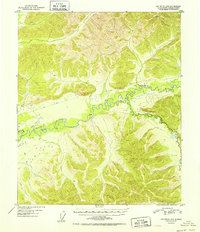
1952 Map of Big Delta D-6
USGS Topo · Published 1952About this map
The winding Chena River dominates this interior landscape as it snakes through the valley during the early 1950s. The river's path is marked by sharp meanders and backwaters like Mullen Slough, highlighting a riverine environment before significant modern development. Transportation in this remote Alaskan corridor relied on seasonal paths, evidenced by a prominent Sled Road that parallels the watercourse to the north, providing a vital overland link across the frozen terrain. Scattered signs of human presence are sparse but significant for the era, including an Airstrip near the riverbank and several isolated Cabin locations that indicate temporary or seasonal habitations for trappers or prospectors. In the eastern portion of the sheet, the South Fork joins the main stem, defining the drainage patterns of the surrounding highlands.
Find a feature on this map
8 named features on this map. Tap any name to fly to it.
Don’t see what you’re looking for? This feature index may not catch every label — zoom into the map to look around manually.
Map Details
Editions of this 1952 Big Delta D-6 Map
2 editions found

Other maps of this area

1945 · Livengood
USGS Topo · 1:250,000

1949 · Fairbanks D-1
USGS Topo · 1:62,500

1949 · Fairbanks C-1
USGS Topo · 1:63,360

1949 · Big Delta C-6
USGS Topo · 1:63,360

1950 · Fairbanks
USGS Topo · 1:250,000

1950 · Big Delta
USGS Topo · 1:250,000

1950 · Big Delta D-6
USGS Topo · 1:63,360

1950 · Fairbanks C-1
USGS Topo · 1:63,360

1951 · Big Delta
USGS Topo · 1:250,000

1951 · Fairbanks
USGS Topo · 1:250,000