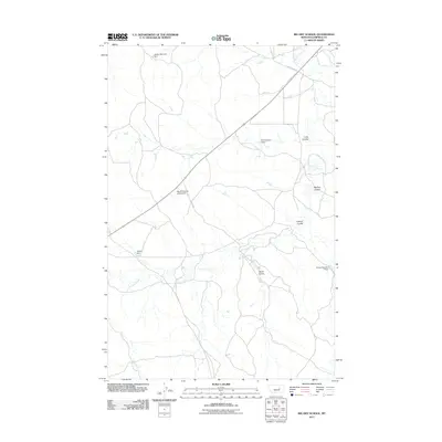
2011 Map of Big Dry School
USGS Topo · Published 2011About this map
The site of the Big Dry School (Historical) stands along Dutton Rd in this sparsely settled region of Garfield County. The landscape is defined by the winding course of Big Dry Creek, which is fed by numerous drainages including Long Coulee, McClay Coulee, and Sloan Coulee. Water management in this arid environment is evident through several small-scale structural features like the Jarden Reservoir Dam and Hooker Dam. Transportation is limited to primary rural routes such as Steve's Fork Rd, which cuts across the high ground between coulees. The distribution of these features reflects the pastoral and ranching-oriented history of eastern Montana, where schools and water sources served as the primary points of social and economic geography.
Find a feature on this map
12 named features on this map. Tap any name to fly to it.
Don’t see what you’re looking for? This feature index may not catch every label — zoom into the map to look around manually.
Map Details
Editions of this 2011 Big Dry School Map
This is the sole edition of this map. No revisions or reprints were ever made.
Other maps of this area

1954 · Jordan
USGS Topo · 1:250,000

1956 · Jordan
USGS Topo · 1:250,000

1958 · Jordan
USGS Topo · 1:250,000

1964 · Jordan
USGS Topo · 1:250,000

1965 · Robertson School
USGS Topo · 1:24,000

1965 · Big Dry School
USGS Topo · 1:24,000

1965 · Edwards
USGS Topo · 1:24,000

1965 · Ziegele Coulee
USGS Topo · 1:24,000
1965 · Fig Mountain
USGS Topo · 1:24,000
1965 · Van Dusen Spring
USGS Topo · 1:24,000