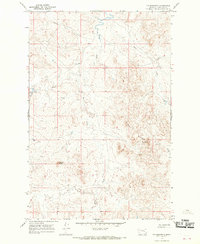
1965 Map of Fig Mountain
USGS Topo · Published 1969About this map
Fig Mountain and the high ridges of the Black Buttes define this Garfield County landscape as it was documented in the mid-1960s. The terrain is deeply incised by a drainage network that includes Sand Creek, Tepee Creek, and the headwaters of Basin Creek. These coulees and creek beds reveal a sparse, ranch-driven environment where water sources and topographic landmarks like Joe Ott Butte are the primary points of reference. The presence of a Drill Hole in the western reaches suggests the era's subterranean exploration, while the winding path of Ziegele Coulee in the north illustrates the natural erosion patterns characteristic of this part of Montana. This survey provides a precise look at the land before later development, preserving the original place names and physical layout of the territory.
Find a feature on this map
9 named features on this map. Tap any name to fly to it.
Don’t see what you’re looking for? This feature index may not catch every label — zoom into the map to look around manually.
Map Details
Editions of this 1965 Fig Mountain Map
This is the sole edition of this map. No revisions or reprints were ever made.
Other maps of this area

1954 · Jordan
USGS Topo · 1:250,000

1954 · Forsyth
USGS Topo · 1:250,000

1956 · Jordan
USGS Topo · 1:250,000

1957 · Forsyth
USGS Topo · 1:250,000

1958 · Jordan
USGS Topo · 1:250,000

1958 · Forsyth
USGS Topo · 1:250,000

1964 · Jordan
USGS Topo · 1:250,000

1965 · Big Dry School
USGS Topo · 1:24,000

1965 · Darby Buttes
USGS Topo · 1:24,000

1965 · Kramer Ranch
USGS Topo · 1:24,000