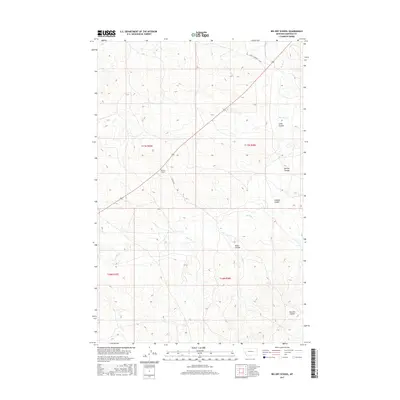
2017 Map of Big Dry School
USGS Topo · Published 2017About this map
Big Dry School stands as a focal point in this sparsely populated section of Garfield County, marking a site of local community importance within a landscape defined by dramatic drainage patterns. The topography is etched by numerous coulees, including McClay Coulee, Graham Coulee, and Sloan Coulee, all of which eventually feed toward the meandering path of Big Dry Cr. These seasonal watercourses carve deep into the plateau, dictating the placement of rural infrastructure such as Steve's Fork Rd and Dutton Rd. The map illustrates a classic Great Plains land division system, with the schoolhouse serving as a rare landmark among the vast, open range of eastern Montana. This 2017 survey provides an essential record of the natural contours and remaining human imprints in a region where cattle ranching and expansive landscapes predominate.
Find a feature on this map
13 named features on this map. Tap any name to fly to it.
Don’t see what you’re looking for? This feature index may not catch every label — zoom into the map to look around manually.
Map Details
Editions of this 2017 Big Dry School Map
This is the sole edition of this map. No revisions or reprints were ever made.
Other maps of this area

1954 · Jordan
USGS Topo · 1:250,000

1956 · Jordan
USGS Topo · 1:250,000

1958 · Jordan
USGS Topo · 1:250,000

1964 · Jordan
USGS Topo · 1:250,000

1965 · Robertson School
USGS Topo · 1:24,000

1965 · Big Dry School
USGS Topo · 1:24,000

1965 · Edwards
USGS Topo · 1:24,000

1965 · Ziegele Coulee
USGS Topo · 1:24,000
1965 · Fig Mountain
USGS Topo · 1:24,000
1965 · Van Dusen Spring
USGS Topo · 1:24,000