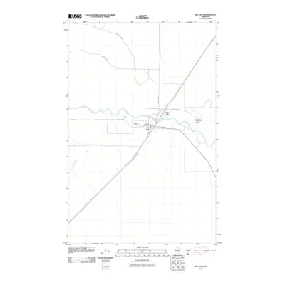
2010 Map of Big Falls
USGS Topo · Published 2010About this map
The Big Fork River meanders through the heart of this Koochiching County landscape, defining the layout of Big Falls and the adjacent community of Grand Falls. This area serves as a significant transit corridor where the Burlington Northern Railroad and the Blue Ox Trl run parallel, cutting a diagonal path through the timbered terrain. The presence of the Big Falls Municipal Airport and the Big Falls Post Office indicates the town's role as a regional service hub for the surrounding wilderness.
Find a feature on this map
18 named features on this map. Tap any name to fly to it.
Don’t see what you’re looking for? This feature index may not catch every label — zoom into the map to look around manually.
Map Details
Editions of this 2010 Big Falls Map
This is the sole edition of this map. No revisions or reprints were ever made.
Other maps of this area

1919 · Happy Land
USGS Topo · 1:62,500

1919 · M
USGS Topo · 1:62,500

1919 · Margie
USGS Topo · 1:62,500

1943 · Lindford
USGS Topo · 1:62,500

1954 · International Falls
USGS Topo · 1:250,000

1957 · International Falls
USGS Topo · 1:250,000

1958 · International Falls
USGS Topo · 1:250,000

1970 · Littlefork SW
USGS Topo · 1:24,000
1970 · Big Falls SE
USGS Topo · 1:24,000
1970 · Lindford SW
USGS Topo · 1:24,000