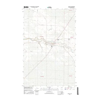
2016 Map of Big Falls
USGS Topo · Published 2016About this map
The Big Fork River carves a winding path through this northern Minnesota landscape, anchoring the settlement of Big Falls and the nearby area of Grand Falls. This 2016 survey highlights a region where the waterway dictated the early structure of the community, now supported by the Big Falls Municipal Airport and a network of rural routes such as Ben Lynn Rd and Daugherty Rd. The town’s grid is clearly visible, featuring streets like Boulevard St and 1st St E that lead toward the riverbank. For those researching local heritage, the Evergreen Cem is located just west of the primary town center. The surrounding terrain is heavily influenced by the township and range system, with vast sections such as t155n r25w defining the administrative and physical geography of this Koochiching County area.
Find a feature on this map
29 named features on this map. Tap any name to fly to it.
Don’t see what you’re looking for? This feature index may not catch every label — zoom into the map to look around manually.
Map Details
Editions of this 2016 Big Falls Map
This is the sole edition of this map. No revisions or reprints were ever made.
Other maps of this area

1919 · Happy Land
USGS Topo · 1:62,500

1919 · M
USGS Topo · 1:62,500

1919 · Margie
USGS Topo · 1:62,500

1943 · Lindford
USGS Topo · 1:62,500

1954 · International Falls
USGS Topo · 1:250,000

1957 · International Falls
USGS Topo · 1:250,000

1958 · International Falls
USGS Topo · 1:250,000

1970 · Littlefork SW
USGS Topo · 1:24,000
1970 · Big Falls SE
USGS Topo · 1:24,000
1970 · Lindford SW
USGS Topo · 1:24,000