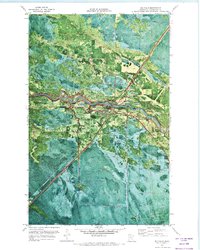
1971 Map of Big Falls
USGS Topo · Published 1973About this map
The Big Fork River carves a winding path through the heart of this Koochiching County landscape, defining the character of Big Falls and nearby Grand Falls. The settlement at Big Falls is positioned at a critical junction where the Burlington Northern line and Highway 71 intersect the river's course. This 1971 orthophotomap provides a distinct visual record of the era's land use, showing the industrial presence of Gravel Pits and a Gaging Station alongside the natural expanse of the Pine Island State Forest. Genealogists may find value in the location of Evergreen Cem north of the village. The map also captures the transition of transportation infrastructure, documenting both an Old Railroad Grade and a Winter Trail, reflecting the area's adaptation to the seasonal demands of the northern Minnesota timber and transit economy.
Find a feature on this map
14 named features on this map. Tap any name to fly to it.
Don’t see what you’re looking for? This feature index may not catch every label — zoom into the map to look around manually.
Map Details
Editions of this 1971 Big Falls Map
This is the sole edition of this map. No revisions or reprints were ever made.
Other maps of this area

1919 · Happy Land
USGS Topo · 1:62,500

1919 · M
USGS Topo · 1:62,500

1919 · Margie
USGS Topo · 1:62,500

1943 · Lindford
USGS Topo · 1:62,500

1954 · International Falls
USGS Topo · 1:250,000

1957 · International Falls
USGS Topo · 1:250,000

1958 · International Falls
USGS Topo · 1:250,000

1970 · Littlefork SW
USGS Topo · 1:24,000
1970 · Big Falls SE
USGS Topo · 1:24,000
1970 · Lindford SW
USGS Topo · 1:24,000