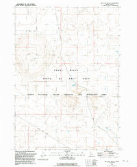
1992 Map of Big Foot Butte
USGS Topo · Published 1992About this map
Big Foot Butte and the volcanic prominence of Basalt Butte dominate this Ada County landscape, reflecting the geologic character of the high desert south of the Boise area. By the early 1990s, much of this terrain was dedicated to federal and military use, split between the Snake River Birds of Prey Area and the Idaho National Guard Training and Maneuver Area. The scarcity of water in this arid environment is highlighted by the presence of Tadpole Lake and Wind Butte Lakes, which serve as critical landmarks alongside Rabbit Creek. Human activity is primarily limited to resource extraction at the Gravel Pit and movement along Range Road, illustrating a region defined more by conservation and training than by permanent settlement.
Find a feature on this map
11 named features on this map. Tap any name to fly to it.
Don’t see what you’re looking for? This feature index may not catch every label — zoom into the map to look around manually.
Map Details
Editions of this 1992 Big Foot Butte Map
This is the sole edition of this map. No revisions or reprints were ever made.
Other maps of this area

1892 · Bisuka
USGS Topo · 1:125,000

1894 · Bisuka
USGS Topo · 1:125,000

1947 · Jackass Butte
USGS Topo · 1:24,000

1947 · Wild Horse Butte
USGS Topo · 1:24,000

1947 · Dorsey Butte
USGS Topo · 1:24,000

1948 · Castle Butte
USGS Topo · 1:24,000

1948 · Big Foot Butte
USGS Topo · 1:24,000

1948 · Wild Horse Butte
USGS Topo · 1:24,000

1948 · Jackass Butte
USGS Topo · 1:24,000

1948 · Dorsey Butte
USGS Topo · 1:24,000