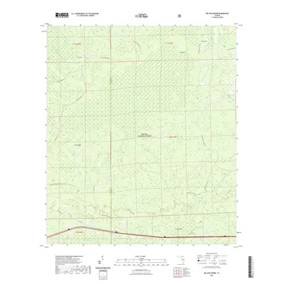
2021 Map of Big Gum Swamp
USGS Topo · Published 2021About this map
Osceola National Forest encompasses the vast majority of this landscape, dominated by complex wetland systems along the border of Columbia and Baker counties. The hydrologic character of the region is defined by expansive reaches like Big Gum Swamp and Little Gum Swamp, which feed into the Middle Prong Saint Marys River in the northeast. This 2021 survey reveals a primitive interior accessed primarily through a network of specialized routes, including the Osceola Wilderness Trl and the Florida National Scenic Trl. Distinctive landforms such as Cross Island and Big Island emerge from the surrounding wetlands, while named features like Impassable Bay and Williams Bay highlight the challenging nature of the terrain. Low-lying basins like Fanny Bay and Brushy Branch are connected by forest roads such as Seventeen Mile Camp Rd, maintaining the area's character as a managed wilderness and critical water conservation area.
Find a feature on this map
29 named features on this map. Tap any name to fly to it.
Don’t see what you’re looking for? This feature index may not catch every label — zoom into the map to look around manually.
Map Details
Editions of this 2021 Big Gum Swamp Map
This is the sole edition of this map. No revisions or reprints were ever made.
Other maps of this area

1954 · Valdosta
USGS Topo · 1:250,000

1958 · Valdosta
USGS Topo · 1:250,000

1959 · Valdosta
USGS Topo · 1:250,000

1961 · Deep Creek
USGS Topo · 1:24,000

1962 · Lake City East
USGS Topo · 1:24,000

1963 · Olustee
USGS Topo · 1:24,000

1963 · Sanderson South
USGS Topo · 1:24,000

1969 · Sanderson NW
USGS Topo · 1:24,000

1969 · Sanderson North
USGS Topo · 1:24,000
1969 · Fairview
USGS Topo · 1:24,000