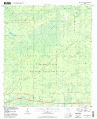
1994 Map of Big Gum Swamp
USGS Topo · Published 1998About this map
Big Gum Swamp dominates this landscape on the border of Columbia and Baker Counties, where the terrain is defined by a dense network of wetlands and forested bays. Part of the Osceola National Forest, the region shows very little human development apart from timber-related access like the Seventeenmile Camp Road. Named terrain features such as Big Island, Cross Island, and Maple Head reveal slightly higher ground amidst the surrounding Buckhead Swamp and Little Gum Swamp.
Find a feature on this map
20 named features on this map. Tap any name to fly to it.
Don’t see what you’re looking for? This feature index may not catch every label — zoom into the map to look around manually.
Map Details
Editions of this 1994 Big Gum Swamp Map
This is the sole edition of this map. No revisions or reprints were ever made.
Other maps of this area

1954 · Valdosta
USGS Topo · 1:250,000

1958 · Valdosta
USGS Topo · 1:250,000

1959 · Valdosta
USGS Topo · 1:250,000

1961 · Deep Creek
USGS Topo · 1:24,000

1962 · Lake City East
USGS Topo · 1:24,000

1963 · Olustee
USGS Topo · 1:24,000

1963 · Sanderson South
USGS Topo · 1:24,000

1969 · Sanderson NW
USGS Topo · 1:24,000

1969 · Sanderson North
USGS Topo · 1:24,000
1969 · Fairview
USGS Topo · 1:24,000