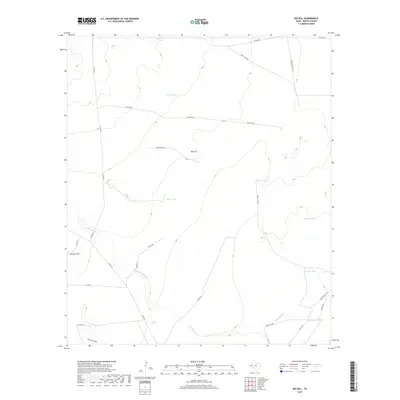
2019 Map of Big Hill
USGS Topo · Published 2019About this map
Big Hill rises as a prominent landmark in this Reeves County landscape, a region defined by arid draws and essential water management features. The area is marked by a network of ranching infrastructure, including numerous named reservoirs such as McIlvain Tank, Kemp Tank, Mare Tank, and Downs Tank. These water sources are scattered across the terrain near Cottonwood Cr and China Draw, illustrating the vital importance of water storage for livestock in the Texas desert. Industrial activity is evident through the presence of a Tank Farm in the southeast corner, along with infrastructure labeled as Gas Line Rd and Oil Line Rd. The map also details a complex system of local access, including Farm Access Rd and various county roads like Co RD 232, which connect these remote resources.
Find a feature on this map
28 named features on this map. Tap any name to fly to it.
Don’t see what you’re looking for? This feature index may not catch every label — zoom into the map to look around manually.
Map Details
Editions of this 2019 Big Hill Map
This is the sole edition of this map. No revisions or reprints were ever made.
Other maps of this area

1921 · Toyah
USGS Topo · 1:125,000

1954 · Pecos
USGS Topo · 1:250,000

1957 · Pecos
USGS Topo · 1:250,000

1968 · W T Ranch
USGS Topo · 1:24,000
1968 · Halamicek Ranch
USGS Topo · 1:24,000

1968 · Mentone SW
USGS Topo · 1:24,000

1970 · Hermosa SW
USGS Topo · 1:24,000

1970 · Big Hill
USGS Topo · 1:24,000

1970 · Toyah
USGS Topo · 1:24,000
1970 · Hermosa
USGS Topo · 1:24,000