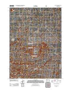
2011 Map of Big Hole
USGS Topo · Published 2011About this map
Big Hole defines this portion of Klamath County, appearing as a prominent geological basin surrounded by a complex network of forest access routes. The landscape is characterized by isolated volcanic features, including Big Hole Butte, Hooligan Hill, and Mowich Spring Butte to the south. This 2011 survey by the U. S. Geological Survey shows a terrain primarily managed for forestry and conservation, with seasonal water features like Dry Creek and Mowich Spring providing critical points of interest in an otherwise arid environment. The intricate system of numbered roads, such as 300 RD and 050 RD, reflects the infrastructure required for contemporary land management and recreation in the high desert region of Oregon.
Find a feature on this map
15 named features on this map. Tap any name to fly to it.
Don’t see what you’re looking for? This feature index may not catch every label — zoom into the map to look around manually.
Map Details
Editions of this 2011 Big Hole Map
This is the sole edition of this map. No revisions or reprints were ever made.
Other maps of this area

1931 · Newberry Crater
USGS Topo · 1:125,000

1935 · Newberry Crater
USGS Topo · 1:125,000

1955 · Crescent
USGS Topo · 1:250,000

1957 · Crescent
USGS Topo · 1:250,000

1958 · Crescent
USGS Topo · 1:250,000
1963 · Spring Butte
USGS Topo · 1:24,000
1963 · Moffitt Butte
USGS Topo · 1:24,000

1970 · Crescent
USGS Topo · 1:250,000

1979 · Crescent
USGS Topo · 1:100,000
1981 · Wickiup Spring
USGS Topo · 1:24,000