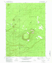
1982 Map of Big Hole
USGS Topo · Published 1982About this map
The boundary between the Deschutes National Forest and the Fremont National Forest bisects this high-elevation terrain, dominated by the massive depression of Big Hole. This geologic feature and the surrounding volcanic heights define a landscape where transit was once critical, evidenced by the Summit Stage Station (Site). The station's location near Summit Butte highlights the historic importance of these passes for travelers moving through the Oregon backcountry before modern infrastructure took hold.
Find a feature on this map
14 named features on this map. Tap any name to fly to it.
Don’t see what you’re looking for? This feature index may not catch every label — zoom into the map to look around manually.
Map Details
Editions of this 1982 Big Hole Map
This is the sole edition of this map. No revisions or reprints were ever made.
Other maps of this area

1931 · Newberry Crater
USGS Topo · 1:125,000

1935 · Newberry Crater
USGS Topo · 1:125,000

1955 · Crescent
USGS Topo · 1:250,000

1957 · Crescent
USGS Topo · 1:250,000

1958 · Crescent
USGS Topo · 1:250,000
1963 · Spring Butte
USGS Topo · 1:24,000
1963 · Moffitt Butte
USGS Topo · 1:24,000

1970 · Crescent
USGS Topo · 1:250,000

1979 · Crescent
USGS Topo · 1:100,000
1981 · Wickiup Spring
USGS Topo · 1:24,000