
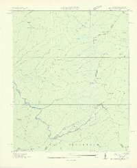
1927 Map of Big Junction
USGS Topo · Published 1927About this map
Whigg Cabin sits high in the high mountain country where the border of Tennessee and North Carolina follows the divide of the Unicoi Mountains. This 1927 survey, compiled in part from early aerial photography by the Tennessee Valley Authority, documents the intricate headwaters of the Tellico River and the Beaverdam River. The landscape is defined by its complex drainage network, where names like Peckerwood Creek, Mistletoe Creek, and Sugar Tree Branch indicate a wilderness used for timbering and grazing. High-altitude clearings such as Stratton Meadow and Swan Meadows appear alongside prominent peaks including Haw Knob and the namesake Big Junction. The map shows a primitive road network crossing at Beech Gap and Hogjaw Gap, marking the early routes through the Cherokee National Forest and Unaka National Forest before modern development.
Find a feature on this map
79 named features on this map. Tap any name to fly to it.
Don’t see what you’re looking for? This feature index may not catch every label — zoom into the map to look around manually.
Map Details
Editions of this 1927 Big Junction Map
2 editions found
Other maps of this area

1893 · Murphy
USGS Topo · 1:125,000

1914 · Murphy
USGS Topo · 1:125,000

1933 · Haw Knob
USGS Topo · 1:48,000

1933 · Whiteoak Flats
USGS Topo · 1:24,000

1933 · Bald River Falls
USGS Topo · 1:24,000

1933 · Rafter
USGS Topo · 1:24,000

1934 · McDaniel Bald
USGS Topo · 1:24,000

1934 · Unaka
USGS Topo · 1:24,000

1934 · Murphy
USGS Topo · 1:48,000

1935 · Marble
USGS Topo · 1:24,000