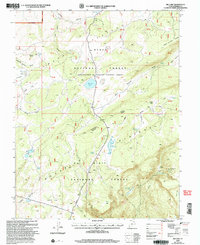
2002 Map of Big Lake
USGS Topo · Published 2005About this map
Aquarius Plateau dominates this high-altitude landscape within the Dixie National Forest, characterized by a complex network of volcanic tables and glacial depressions. This 2002 revision shows a region defined by its water resources, featuring numerous small bodies of water such as Big Lake, Lake Philo, and the Indian Spr Reservoir. The drainage patterns are clearly visible through features like Branch Pine Creek and Jubilee Creek, which carve through the high terrain.
Find a feature on this map
51 named features on this map. Tap any name to fly to it.
Don’t see what you’re looking for? This feature index may not catch every label — zoom into the map to look around manually.
Map Details
Editions of this 2002 Big Lake Map
This is the sole edition of this map. No revisions or reprints were ever made.
Other maps of this area

1885 · Fish Lake
USGS Topo · 1:250,000

1886 · Escalante
USGS Topo · 1:250,000

1896 · Fish Lake
USGS Topo · 1:250,000

1953 · Loa 4 NE
USGS Topo · 1:24,000

1956 · Escalante
USGS Topo · 1:250,000

1956 · Salina
USGS Topo · 1:250,000

1960 · Escalante
USGS Topo · 1:250,000

1960 · Salina
USGS Topo · 1:250,000

1962 · Salina
USGS Topo · 1:250,000

1964 · Barker Reservoir
USGS Topo · 1:24,000