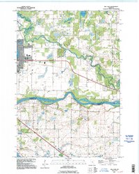
1991 Map of Big Lake
USGS Topo · Published 1995About this map
The Mississippi River creates a prominent natural boundary between Sherburne and Wright counties, anchoring this landscape of glacial lakes and river bends in the early 1990s. The settlement of Big Lake serves as a central hub, situated near the shores of Lake Mitchell and the namesake Big Lake, while further south, the Otsego Corporate Boundary meets the river's edge. The geography is defined by a dense network of water bodies, from Birch Lake in the north to the southern reaches of Pelican Lake. Transport and infrastructure are visible through the proximity of the Elk River and the small community of Bailey, which includes a local Cem. This survey also documents the industrial presence of a Gravel Pit and utility landmarks like the Comm Tower, reflecting the mix of residential growth and rural resource use typical of this river-valley corridor.
Find a feature on this map
20 named features on this map. Tap any name to fly to it.
Don’t see what you’re looking for? This feature index may not catch every label — zoom into the map to look around manually.
Map Details
Editions of this 1991 Big Lake Map
This is the sole edition of this map. No revisions or reprints were ever made.
Other maps of this area

1909 · Rockford
USGS Topo · 1:62,500

1953 · Stillwater
USGS Topo · 1:250,000

1955 · Stillwater
USGS Topo · 1:250,000

1958 · Stillwater
USGS Topo · 1:250,000

1958 · Rockford
USGS Topo · 1:62,500

1958 · Buffalo
USGS Topo · 1:62,500

1961 · Big Lake
USGS Topo · 1:24,000

1961 · Orrock
USGS Topo · 1:24,000

1961 · Lake Fremont
USGS Topo · 1:24,000

1961 · Elk River
USGS Topo · 1:24,000