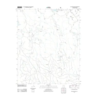
2011 Map of Big Lake South
USGS Topo · Published 2011About this map
West Fork Black River carves a deep path through this high-altitude landscape in the Apache-Sitgreaves National Forest, serving as a primary drainage for the surrounding ridges and knolls. The area is defined by its extensive water management for livestock and wildlife, visible through dozens of named stock tanks such as Upper Horse Tank Number One and Section Twenty-Eight Tank. For researchers of local ranching history, the presence of the Reservation Ranch and P S Ranch highlights the enduring cattle operations of this region. Outdoor recreation infrastructure is well-established near the northern shores of Big Lake, with multiple sites like Brookchar Campground and Cutthroat Campground serving visitors. Fire surveillance remains a critical component of the landscape, marked by the prominent Big Lake Lookout and the P S Knoll Lookout Tower on its namesake peak.
Find a feature on this map
97 named features on this map. Tap any name to fly to it.
Don’t see what you’re looking for? This feature index may not catch every label — zoom into the map to look around manually.
Map Details
Editions of this 2011 Big Lake South Map
This is the sole edition of this map. No revisions or reprints were ever made.
Other maps of this area

1922 · Nutrioso
USGS Topo · 1:125,000

1954 · Clifton
USGS Topo · 1:250,000

1957 · Clifton
USGS Topo · 1:250,000

1958 · Clifton
USGS Topo · 1:250,000

1958 · Hannagan Meadow
USGS Topo · 1:62,500

1958 · Big Lake
USGS Topo · 1:62,500

1962 · Clifton
USGS Topo · 1:250,000
1967 · Bonito Rock
USGS Topo · 1:24,000
1967 · Mount Ord
USGS Topo · 1:24,000
1967 · Maverick
USGS Topo · 1:24,000