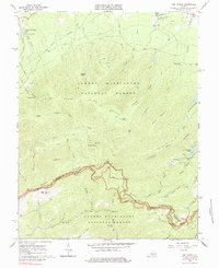
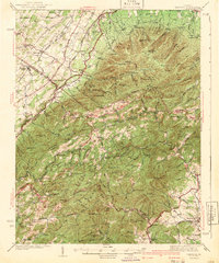
1965 Map of Big Levels
USGS Topo · Published 1984About this map
Big Levels dominates the high plateau of the George Washington National Forest, where the complex ridge-and-valley topography of Augusta and Nelson counties meets. In the mid-1960s, this area supported both heavy industry and growing recreation. The map records several mines and claypits scattered along the slopes of Mine Bank Mtn and Turkey Pen Ridge, while the Blue Ridge Parkway traces the crest of the Blue Ridge mountains. Recreational hubs like Shenandoah Acres and Sherando Lake are prominent, along with established sites such as Camp Thunderbird and the Kennedy Fields Campgrounds. Local heritage is anchored by landmarks like Rankin Ch and the White Rock Cem, alongside numerous overlooks including The Slacks Overlook and The Priest Overlook that provide vantage points over the Saint Marys River and its surrounding peaks.
Find a feature on this map
62 named features on this map. Tap any name to fly to it.
Don’t see what you’re looking for? This feature index may not catch every label — zoom into the map to look around manually.
Map Details
Editions of this 1965 Big Levels Map
4 editions found
Other maps of this area

1892 · Buckingham
USGS Topo · 1:125,000

1892 · Harrisonburg
USGS Topo · 1:125,000

1894 · Staunton
USGS Topo · 1:125,000

1894 · Lexington
USGS Topo · 1:125,000

1934 · Waynesboro
USGS Topo · 1:48,000

1936 · Vesuvius
USGS Topo · 1:48,000

1939 · Waynesboro
USGS Topo · 1:62,500
1941 · Vesuvius
USGS Topo · 1:62,500
1943 · Lovingston
USGS Topo · 1:62,500
1944 · Staunton
USGS Topo · 1:62,500