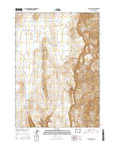
2017 Map of Big Mud Flat
USGS Topo · Published 2017About this map
Big Mud Flat serves as the namesake for this high-desert landscape in Malheur County, where the management of water is the defining human footprint. Numerous man-made catchments, including Knottingham Reservoir, Harry Page Reservoir, and Ben Odell Reservoir, are distributed across the terrain, suggesting the area's importance for livestock grazing or wildlife management. The landscape transitions from the broad, open expanses of the flats into the intricate drainages of Black Canyon and Juniper Canyon.
Find a feature on this map
24 named features on this map. Tap any name to fly to it.
Don’t see what you’re looking for? This feature index may not catch every label — zoom into the map to look around manually.
Map Details
Editions of this 2017 Big Mud Flat Map
This is the sole edition of this map. No revisions or reprints were ever made.
Other maps of this area

1955 · Boise
USGS Topo · 1:250,000

1958 · Boise
USGS Topo · 1:250,000

1962 · Boise
USGS Topo · 1:250,000

1967 · Diamond Butte
USGS Topo · 1:24,000

1967 · Quartz Mtn Basin
USGS Topo · 1:24,000

1969 · Jordan Craters North
USGS Topo · 1:24,000

1972 · Cedar Mountain
USGS Topo · 1:24,000

1972 · Big Mud Flat
USGS Topo · 1:24,000
1972 · Wall Rock Springs
USGS Topo · 1:24,000
1972 · Rinehart Canyon
USGS Topo · 1:24,000