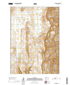
2020 Map of Big Mud Flat
USGS Topo · Published 2020About this map
Big Mud Flat dominates the northwestern portion of this high-desert landscape in Malheur County, where the management of water is central to the human footprint. The region is marked by a network of catchments and natural sources, including Knottingham Reservoir, Harry Page Reservoir, and David Kent Reservoir, alongside reliable points like Willow Springs and Whiskey Springs. These features suggest a history of ranching and livestock management on the open range. To the east, the terrain shifts abruptly at the Owyhee Breaks, a sharp descent into a complex of drainages. The southern reaches are defined by the deepening of Black Canyon and Juniper Canyon, leading toward the Wrangle Basin. The layout of Mud Flat Rd and Turner Rd indicates how this remote territory is navigated across vast township and range sections.
Find a feature on this map
23 named features on this map. Tap any name to fly to it.
Don’t see what you’re looking for? This feature index may not catch every label — zoom into the map to look around manually.
Map Details
Editions of this 2020 Big Mud Flat Map
This is the sole edition of this map. No revisions or reprints were ever made.
Other maps of this area

1955 · Boise
USGS Topo · 1:250,000

1958 · Boise
USGS Topo · 1:250,000

1962 · Boise
USGS Topo · 1:250,000

1967 · Diamond Butte
USGS Topo · 1:24,000

1967 · Quartz Mtn Basin
USGS Topo · 1:24,000

1969 · Jordan Craters North
USGS Topo · 1:24,000

1972 · Cedar Mountain
USGS Topo · 1:24,000

1972 · Big Mud Flat
USGS Topo · 1:24,000
1972 · Wall Rock Springs
USGS Topo · 1:24,000
1972 · Rinehart Canyon
USGS Topo · 1:24,000