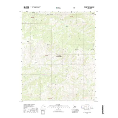
2018 Map of Big Pine Mountain
USGS Topo · Published 2018About this map
San Rafael Mountains and the Sierra Madre Mountains converge in this high-elevation portion of the Los Padres National Forest. The landscape is defined by the significant prominence of Big Pine Mtn and Samon Peak, which tower over a complex network of drainage systems including Indian Cr and the Sisquoc River. Human presence is minimal, primarily represented by the winding Big Pine Rd and a few named clearings like Jackrabbit Flat and Mission Pine Basin. Water sources in this arid, high-country environment are critical landmarks, noted by features such as Chokecherry Spring and the deeply cut Judell Canyon. The map captures a wilderness area where terrain dictates movement, with narrow canyons like Rattlesnake Canyon and Alamar Canyon providing the primary corridors through the high peaks.
Find a feature on this map
25 named features on this map. Tap any name to fly to it.
Don’t see what you’re looking for? This feature index may not catch every label — zoom into the map to look around manually.
Map Details
Editions of this 2018 Big Pine Mountain Map
This is the sole edition of this map. No revisions or reprints were ever made.
Other maps of this area

1902 · Santa Ynez
USGS Topo · 1:125,000

1905 · Santa Ynez
USGS Topo · 1:125,000

1941 · San Rafael Mtn.
USGS Topo · 1:62,500

1941 · McPherson Peak
USGS Topo · 1:62,500

1942 · San Rafael Mtn.
USGS Topo · 1:62,500

1942 · Little Pine Mountain
USGS Topo · 1:24,000

1943 · Big Pine Mountain
USGS Topo · 1:31,680

1943 · San Rafael Mtn.
USGS Topo · 1:62,500

1943 · McPherson Peak
USGS Topo · 1:62,500

1943 · Hildreth Peak
USGS Topo · 1:24,000