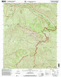
1995 Map of Big Pine Mountain
USGS Topo · Published 2000About this map
The San Rafael Mountains dominate this high-elevation region of the Los Padres National Forest, where conservation and wilderness management define the land use in the mid-1990s. This survey highlights the Sisquoc Condor Sanctuary and the protected corridor of the Sisquoc Wild and Scenic River, reflecting a period focused on preserving critical habitat for the California Condor. The landscape is a network of remote campsites and footpaths, including the Mission Pine Trail and Grapevine Trail, which connect isolated spots like Jackrabbit Flat and Mansfield Campsite. A system of fire roads and ridge-line routes, such as Santa Lucia Road and Big Pine Road, provide the only vehicular access through the San Rafael Wilderness and Dick Smith Wilderness to landmarks like the Big Pine Mountain lookout and a solitary Guard Station.
Find a feature on this map
52 named features on this map. Tap any name to fly to it.
Don’t see what you’re looking for? This feature index may not catch every label — zoom into the map to look around manually.
Map Details
Editions of this 1995 Big Pine Mountain Map
This is the sole edition of this map. No revisions or reprints were ever made.
Other maps of this area

1902 · Santa Ynez
USGS Topo · 1:125,000

1905 · Santa Ynez
USGS Topo · 1:125,000

1941 · San Rafael Mtn.
USGS Topo · 1:62,500

1941 · McPherson Peak
USGS Topo · 1:62,500

1942 · San Rafael Mtn.
USGS Topo · 1:62,500

1942 · Little Pine Mountain
USGS Topo · 1:24,000

1943 · Big Pine Mountain
USGS Topo · 1:31,680

1943 · San Rafael Mtn.
USGS Topo · 1:62,500

1943 · McPherson Peak
USGS Topo · 1:62,500

1943 · Hildreth Peak
USGS Topo · 1:24,000