
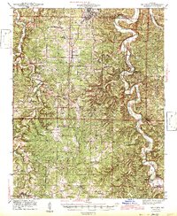
1943 Map of Big Piney
USGS Topo · Published 1943About this map
Fort Leonard Wood dominates the northern landscape of this Missouri Ozarks region, surveyed between 1932 and 1941. The installation borders the Mark Twain National Forest, illustrating a mid-century shift toward military and federal land use in Pulaski and Texas counties. Winding through the center of the sheet, the Big Piney River carves a deep path past landmarks like Wildcat Shoal and Ross Bridge, anchoring a rural economy of small settlements and river crossings. Small communities like Bloodland, Cookville, and Hazleton are mapped alongside an extensive network of country schools, such as Lone Star Sch and Cedar Bluff Sch, many of which served dispersed farmsteads before being impacted by the expansion of the fort. Notable local sites include Berry Cave, the Roby Lookout tower, and the St Annie Ch, providing a detailed look at the social and topographic fabric of the area just as the Second World War began to transform the local geography.
Find a feature on this map
97 named features on this map. Tap any name to fly to it.
Don’t see what you’re looking for? This feature index may not catch every label — zoom into the map to look around manually.
Map Details
Editions of this 1943 Big Piney Map
2 editions found
Other maps of this area

1912 · Rolla
USGS Topo · 1:62,500

1931 · Manes
USGS Topo · 1:48,000

1936 · Waynesville
USGS Topo · 1:48,000

1937 · Edgar Springs
USGS Topo · 1:48,000

1941 · Big Piney
USGS Topo · 1:62,500

1941 · Manes
USGS Topo · 1:62,500

1941 · Bado
USGS Topo · 1:62,500

1942 · Waynesville
USGS Topo · 1:62,500

1943 · Richland
USGS Topo · 1:62,500

1943 · Manes
USGS Topo · 1:62,500