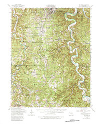
1954 Map of Big Piney
USGS Topo · Published 1984About this map
The Fort Leonard Wood Military Reservation dominates the northern half of this Missouri landscape, encompassing established communities and local institutions in the mid-1950s. The settlement of Bloodland is clearly visible with its Bloodland High School, Bloodland Church, and Bloodland Cemetery, serving as a central hub for families in the area. To the south and east, the Mark Twain National Forest provides a contrasting topography of wooded hollows and creek beds, including Paddie Hollow and Musgrave Hollow.
Find a feature on this map
56 named features on this map. Tap any name to fly to it.
Don’t see what you’re looking for? This feature index may not catch every label — zoom into the map to look around manually.
Map Details
Editions of this 1954 Big Piney Map
3 editions found
Other maps of this area

1912 · Rolla
USGS Topo · 1:62,500

1931 · Manes
USGS Topo · 1:48,000

1936 · Waynesville
USGS Topo · 1:48,000

1937 · Edgar Springs
USGS Topo · 1:48,000

1941 · Big Piney
USGS Topo · 1:62,500

1941 · Manes
USGS Topo · 1:62,500

1941 · Bado
USGS Topo · 1:62,500

1942 · Waynesville
USGS Topo · 1:62,500

1943 · Richland
USGS Topo · 1:62,500

1943 · Big Piney
USGS Topo · 1:62,500