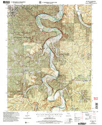
2004 Map of Big Piney
USGS Topo · Published 2006About this map
The Big Piney River carves a deep, winding course through the heart of the Mark Twain National Forest, defining the rugged topography of southern Pulaski County. This landscape is a patchwork of federal stewardship and military history, dominated by the eastern reaches of the Fort Leonard Wood Military Reservation and its restricted training grounds. Settlement patterns are concentrated along the river valley and high ridges, including the small communities of Big Piney and Duke. Evidence of early Ozark life is found in several family and community landmarks, such as Ramsey Cemetery, Hopewell Church, and the former Democrat School (Site). The river remains a central feature for both industry and recreation, noted by the presence of Ross Bridge, the Post Golf Course, and Stone Mill Spring. A unique transition is visible where the forest meets the military boundary, marked by the Bradford Cemetery Ruins and numerous hollows like McCourtney Hollow and Wildcat Hollow.
Find a feature on this map
35 named features on this map. Tap any name to fly to it.
Don’t see what you’re looking for? This feature index may not catch every label — zoom into the map to look around manually.
Map Details
Editions of this 2004 Big Piney Map
This is the sole edition of this map. No revisions or reprints were ever made.
Other maps of this area

1912 · Rolla
USGS Topo · 1:62,500

1936 · Waynesville
USGS Topo · 1:48,000

1937 · Edgar Springs
USGS Topo · 1:48,000

1941 · Big Piney
USGS Topo · 1:62,500

1942 · Waynesville
USGS Topo · 1:62,500

1943 · Big Piney
USGS Topo · 1:62,500

1944 · Waynesville
USGS Topo · 1:62,500

1945 · Edgar Springs
USGS Topo · 1:62,500

1949 · Rolla
USGS Topo · 1:250,000
1950 · Kaintuck Hollow
USGS Topo · 1:24,000