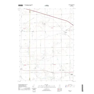
2018 Map of Big Rock
USGS Topo · Published 2018About this map
Big Rock and Kaneville anchor this agricultural landscape along the border of DeKalb and Kane counties. The terrain is defined by the branching network of Big Rock Creek, including the E Br Big Rock Cr and W Br Big Rock Cr, which have historically shaped the layout of local farmsteads and transport routes. This 2018 survey reveals a modern rural structure where small-town life persists alongside specialized landmarks like the Oakfield RLA Airport and J Maddock Airport. Genealogists will find significant local history at the Kaneville Cem, West Big Rock Cem, and Community Methodist Cem. The map traces a grid of named rural roads, such as Harter Rd and Dauberman Rd, that connect the hamlet of Troxel to the expanding edges of Sugar Grove in the southeast corner.
Find a feature on this map
59 named features on this map. Tap any name to fly to it.
Don’t see what you’re looking for? This feature index may not catch every label — zoom into the map to look around manually.
Map Details
Editions of this 2018 Big Rock Map
This is the sole edition of this map. No revisions or reprints were ever made.
Other maps of this area

1925 · Yorkville
USGS Topo · 1:62,500

1932 · Geneva
USGS Topo · 1:62,500

1937 · Sycamore
USGS Topo · 1:62,500

1948 · Geneva
USGS Topo · 1:62,500

1948 · Sandwich
USGS Topo · 1:62,500

1950 · Sandwich
USGS Topo · 1:62,500

1953 · Yorkville
USGS Topo · 1:24,000
1954 · Yorkville
USGS Topo · 1:62,500

1958 · Aurora
USGS Topo · 1:250,000

1961 · Aurora
USGS Topo · 1:250,000