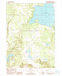
1990 Map of Big Sage Reservoir
USGS Topo · Published 1990About this map
Modoc National Forest encompasses the vast majority of this high-altitude terrain in Northern California, defined by a complex network of water management features and seasonal drainages. The expansive Big Sage Reservoir dominates the northern landscape, while smaller impoundments such as Upper Cummings Res, Lower Cummings Res, Kelley Reservoir, and Essex Reservoir illustrate the hydraulic engineering required to support this arid region. The topography transitions from the heights of Whittemore Ridge and the Porcupine Valley rim down into Salisbury Gulch. Small-scale resource extraction is evidenced by a Borrow Pit and a lone Prospect, suggesting a landscape used primarily for forest management and water storage during the late twentieth century. Natural water sources like Mill Springs and Rock Springs provide contrast to the larger artificial reservoirs.
Find a feature on this map
16 named features on this map. Tap any name to fly to it.
Don’t see what you’re looking for? This feature index may not catch every label — zoom into the map to look around manually.
Map Details
Editions of this 1990 Big Sage Reservoir Map
This is the sole edition of this map. No revisions or reprints were ever made.
Other maps of this area

1886 · Alturas
USGS Topo · 1:250,000

1892 · Alturas
USGS Topo · 1:250,000

1954 · Alturas
USGS Topo · 1:250,000

1958 · Alturas
USGS Topo · 1:250,000

1961 · Canby
USGS Topo · 1:62,500

1961 · Alturas
USGS Topo · 1:62,500

1962 · Alturas
USGS Topo · 1:250,000

1962 · Big Sage Reservoir
USGS Topo · 1:62,500

1962 · Jacks Butte
USGS Topo · 1:62,500

1965 · Alturas
USGS Topo · 1:250,000