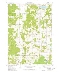
1975 Map of Big Spring
USGS Topo · Published 1978About this map
Big Spring and the surrounding township of New Haven characterize this 1970s landscape at the intersection of Adams and Columbia counties. The map captures a transition between the organized agricultural grids of Dell Prairie and the recreational developments surrounding Jordan Lake and Mason Lake. A distinct ecclesiastical presence is noted at Davis Corners Ch in the settlement of Davis Corners, while a centralized Townhall serves the community further east. The local economy and land use are visible through features like a Sandpit and Gravel Pit, alongside infrastructure such as the Radio Tower (WNNO) and the Sewage Disposal Ponds. The presence of numerous Campgrounds and a Golf Course reflects the area's mid-century evolution toward a vacation and leisure destination within the central Wisconsin plains.
Find a feature on this map
42 named features on this map. Tap any name to fly to it.
Don’t see what you’re looking for? This feature index may not catch every label — zoom into the map to look around manually.
Map Details
Editions of this 1975 Big Spring Map
This is the sole edition of this map. No revisions or reprints were ever made.
Other maps of this area

1901 · The Dells
USGS Topo · 1:62,500

1902 · Briggsville
USGS Topo · 1:62,500

1957 · Wisconsin Dells
USGS Topo · 1:62,500

1957 · Madison
USGS Topo · 1:250,000

1958 · Briggsville
USGS Topo · 1:62,500

1960 · Madison
USGS Topo · 1:250,000

1961 · Oxford
USGS Topo · 1:62,500

1961 · Adams
USGS Topo · 1:62,500
1975 · Wisconsin Dells SE
USGS Topo · 1:24,000
1975 · Wisconsin Dells NE
USGS Topo · 1:24,000