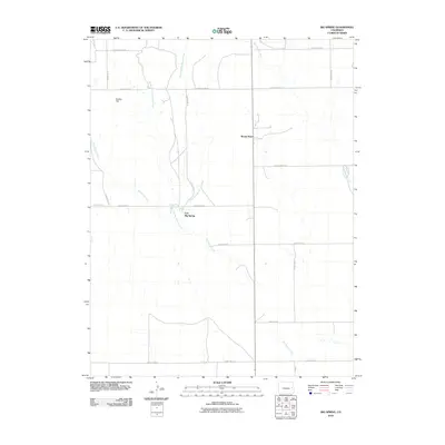
2010 Map of Big Spring
USGS Topo · Published 2010About this map
Mount Pearl and Fort Big Spring anchor this high plains landscape in eastern Colorado, where the drainage network of the Big Spring Creek basin dictates the geography. The map illustrates a sparse but structured grid of rural infrastructure, with County Road DD and County Road V framing the upper and lower limits of the survey area. Water sources are critical in this arid environment, marked by the convergences of the East Fork Big Spring Creek, Middle Fork Big Spring Creek, and Little Spring Creek. A prominent terrain landmark, Eureka Hill, rises in the northwest, overlooking the various forks that eventually feed into the main branch of Big Spring. This cartographic record is a study in the intersection of traditional township-range road systems and the natural hydrology that historically influenced settlement patterns and livestock grazing in Cheyenne County.
Find a feature on this map
19 named features on this map. Tap any name to fly to it.
Don’t see what you’re looking for? This feature index may not catch every label — zoom into the map to look around manually.
Map Details
Editions of this 2010 Big Spring Map
This is the sole edition of this map. No revisions or reprints were ever made.
Other maps of this area

1891 · Kit Carson
USGS Topo · 1:125,000

1893 · Kit Carson
USGS Topo · 1:125,000

1954 · Limon
USGS Topo · 1:250,000

1954 · Lamar
USGS Topo · 1:250,000

1957 · Limon
USGS Topo · 1:250,000

1958 · Limon
USGS Topo · 1:250,000

1958 · Lamar
USGS Topo · 1:250,000

1979 · Stratton 3 SE
USGS Topo · 1:24,000
1979 · Stratton 3 SW
USGS Topo · 1:24,000
1979 · Alpine Ranch SW
USGS Topo · 1:24,000